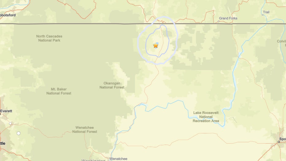
OKANOGAN COUNTY, Wash. – A 3.1 magnitude earthquake struck near Tonasket on Wednesday morning, following a series of rumbles over the last week in the area.

The USGS initially reported Wednesday’s 7:23 a.m. earthquake as a magnitude 3.0, but it was later upgraded to 3.1 after further review.
According to the United States Geological Survey (USGS), the quake hit at around 7:23 a.m. a little less than six miles northwest of Tonasket. So far, the USGS has received 57 responses from people who felt this particular quake.
Earthquakes occur nearly every day in Washington, according to the Department of Natural Resources. While there are many variables involved, geologists say damage does not usually happen until an earthquake’s magnitude reaches somewhere above 4 or 5.
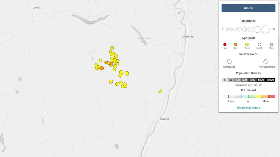
The USGS earthquake map shows increased seismic activity in this part of Okanogan County. In the past week, 37 small quakes have been recorded in the region bordered by the cities of Tonasket, Ellisforde and Loomis.

According to the USGS earthquake map, there have been around 37 earthquakes recorded in the Tonasket, Washington area over the last week. (United States Geological Survey)
How many earthquakes struck near Tonasket, WA in the last week?
Timeline:
Of the 37 earthquakes recorded in the past week, three had a magnitude of 3.0 or higher.
- 3.1M at 7:23 a.m. Wednesday, April 16
- 1.8M at 2:44 p.m. Tuesday, April 15
- 1.2M at 11:13 a.m. Tuesday, April 15
- 1.2M at 4:55 a.m. Tuesday, April 15
- 1.6M at 10:30 p.m. on Monday, April 14
- 1.3M at 8:24 p.m. on Monday, April 14
- 2.8M at 6:55 p.m. on Monday, April 14
- 1.1M at 4:49 a.m. on Monday, April 14
- 1.2M at 2:52 a.m. on Monday, April 14
- 1.0M at 1:32 a.m. on Monday, April 14
- 1.6M at 1:13 a.m. on Monday, April 14
- 1.1M at 12:01 a.m. on Monday, April 14
- 1.3M at 6:56 p.m. on Sunday, April 13
- 2.5M at 1:19 p.m. on Sunday, April 13
- 2.1M at 11:42 a.m. on Sunday, April 13
- 1.4M at 7:24 a.m. on Sunday, April 13
- 1.3M at 5:39 a.m. on Sunday, April 13
- 1.3M at 5:18 a.m. on Sunday, April 13
- 1.5M at 5:07 a.m. on Sunday, April 13
- 3.2M at 4:01 a.m. on Sunday, April 13
- 1.1M at 3:45 a.m. on Sunday, April 13
- 1.5M at 1:36 a.m. on Sunday, April 13
- 1.7M at 12:19 a.m. on Sunday, April 13
- 2.2M at 11:58 p.m. on Saturday, April 12
- 2.7M at 10:00 p.m. on Saturday, April 12
- 2.5M at 9:49 p.m. on Saturday, April 12
- 1.9M at 8:41 p.m. on Saturday, April 12
- 2.2M at 8:30 p.m. on Saturday, April 12
- 2.0M at 8:29 p.m. on Saturday, April 12
- 2.9M at 8:11 p.m. on Saturday, April 12
- 1.7M at 7:55 p.m. on Saturday, April 12
- 1.9M at 7:35 p.m. on Saturday, April 12
- 2.4M at 7:17 p.m. on Saturday, April 12
- 1.5M at 7:08 p.m. on Saturday, April 12
- 1.7M at 7:01 p.m. on Saturday, April 12
- 1.8M at 7:00 p.m. on Saturday, April 12
- 3.1M at 6:46 p.m. on Saturday, April 12
What you can do:
Anyone who felt Wednesday’s 3.0 magnitude earthquake near Tonasket is encouraged to report it to the USGS.
The Source: Information for this story came from the United States Geological Survey and the Washington State Department of Natural Resources.
MORE HEADLINES FROM FOX 13 SEATTLE
Seattle woman arrested for pit bull attacks: ‘Let him do his thing’
FEMA denies $34M in funds for WA bomb cyclone relief, gives no explanation
WSDOT shuts down 103-year-old bridge in Pierce County, WA
Man accused in Seattle hate crime flips off cameras, storms out of courtroom
Elephants react to San Diego earthquake, swarm around young
Red Robin launching Bottomless Burger Pass for National Burger Month
To get the best local news, weather and sports in Seattle for free, sign up for the daily FOX Seattle Newsletter.
Download the free FOX LOCAL app for mobile in the Apple App Store or Google Play Store for live Seattle news, top stories, weather updates and more local and national coverage, plus 24/7 streaming coverage from across the nation.

